Rules are in place specific to all vessels operating within these defined port areas.
Vessels under pilotage have right of way
Any vessel over 35 metres operating within the pilotage area of a defined port, must carry a licensed marine pilot, or be under the command of a master who holds a pilotage exemption certificate for that area.
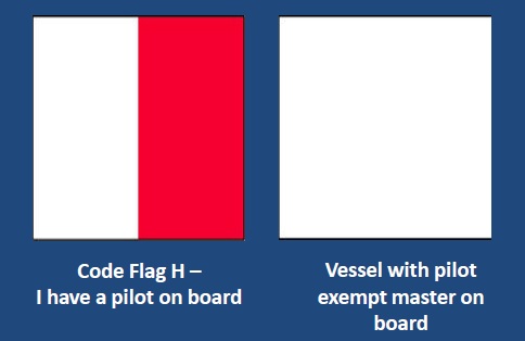
A vessel with a pilot on board is required to show the international Code Flag ‘H’.
A vessel with a pilot exempt Master on board is required to fly a plain white flag.
Every vessel, commercial and recreational, motor or sail, must give way to ocean going ships under the command of a Pilot, or a Pilot Exempt master.
Boaters should be aware of expected shipping movements before going out on the water. These are published in daily newspapers and can be found on the Tasports website below.
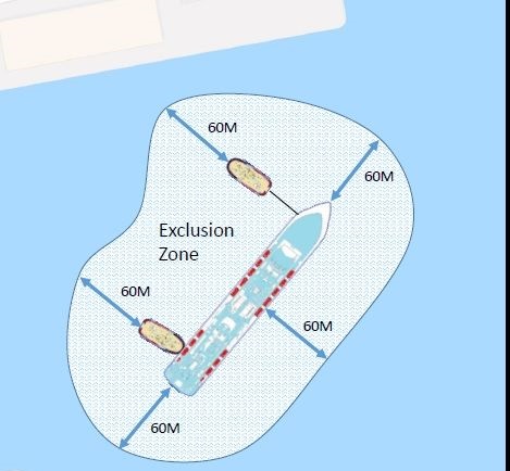
Prohibited Area around vessels engaged in berthing operations
Commercial port areas exist in our waterways that are used regularly by recreational boats, kayakers and rowers. These are shared waterways, however recreational vessels should be vigilant when large commercial vessels are being manoeuvred and berthed.
Significant and dangerous wash can be produced by these large vessels and their attendant tugs during berthing operations. The wash can have serious adverse effects on the safety of other vessels in the vicinity.
Commercial vessels under pilotage also have right of way over any other vessel within port areas. The manoeuvring and positioning of these large vessels onto their berth require a measured approach that does not involve interference from other vessels.
A 60 metre prohibited zone exists around:
- any vessel that is under pilotage and engaged in berthing operations; and
- any attendant tug that is assisting in the berthing operation
Waterway users should also be aware that large cruise ships that are secured alongside a berth can at any time use their thrusters. For this reason, it is advised to keep well clear of these vessels at all times when they are berthed.
Defined Ports
The following areas are defined ports in accordance with the Marine and Safety (Pilotage and Navigation) Regulations 2017.
| Defined Ports | Meaning |
| Port of Burnie | means all the waters bounded by an imaginary circle having a radius of 3 nautical miles and centred at the eastern end of the Island Breakwater in Emu Bay; |
| Port of Coles Bay | means all the waters – (a) to the east of an imaginary straight line drawn between Hepburn Point and the westernmost point of Schouten Island, including Schouten Passage; and (b) to the west of an imaginary straight line drawn between Cape Tourville and Cape Forestier; and (c) to the west of an imaginary straight line drawn between Cape Forestier and Cape Sonnerat, including Schouten Passage; |
| Port of Devonport | means all the waters bounded by an imaginary circle centred at Mersey Bluff Lighthouse having a radius of 3 nautical miles, including the waters of the River Mersey up to, but not including, the Victoria Bridge; |
| Port of Grassy | means all the waters bounded by an imaginary circle having a radius of 3 nautical miles and centred at the outer extremity of the reclamation at Grassy Harbour; |
| Port of Hobart | means the area comprising Zones A, B and C as defined in regulation 6; |
| Port of Lady Barron | means all the waters bounded by an imaginary circle having a radius of 3 nautical miles and centred at the outer extremity of the wharf situated in Adelaide Bay; |
| Port of Launceston | means all the waters bounded by an imaginary circle having a radius of 3 nautical miles and centred on Low Head and including the area comprising Zones D and E as defined in regulation 6; |
| Port of Naracoopa | means all the waters bounded by an imaginary circle having a radius of 3 nautical miles and centred at the outer extremity of the port operator jetty situated at Naracoopa; |
| Port of Port Arthur | means all the waters lying northwards of an imaginary straight line drawn from the south-eastern extremity of West Arthur Head direct to the southern most point of Budget Head; |
| Port of Port Davey | means – (a) all the waters lying eastward of an imaginary straight line drawn from a point at North Head where the parallel of latitude 43019’18.65″ South intersects the coastline to a point at Hilliard Head where the parallel of latitude 43023’15.41″ South intersects the coastline, including all the waters of Payne Bay and Hannan Inlet; and (b) all bays and estuaries opening into Bathurst Harbour; |
| Port of Port Latta | means all the waters bounded by an imaginary circle having a radius of 3 nautical miles and centred at the outer extremity of the ore-loading jetty; |
| Port of Spring Bay | means all the waters of Spring Bay westward of an imaginary straight line drawn across the approaches to Spring Bay extending from Point Home Lookout to Stapleton Point; |
| Port of Stanley | means all the waters bounded by an imaginary circle having a radius of 2.5 nautical miles and centred on Circular Head; |
| Port of Strahan | means all the waters of Macquarie Harbour and all bays and estuaries opening into that harbour, but not beyond an imaginary line bearing 000 degrees for a distance of 1.20 kilometres from Watts Hill and thence bearing 090 degrees to the shoreline. |
Vessels to maintain a listening watch on relevant VHF Channel when approaching or in a pilotage area
Any vessel within a pilotage area should maintain a listening watch on the VHF working channel used by Vessel Traffic Services (VTS) within that pilotage area, if the vessel is fitted with a VHF radio. In southern Tasmanian pilotage areas the VTS working channel is VHF channel 12. In Northern Tasmanian pilotage areas the VTS working Channel is VHF Channel 14. These working channels are monitored and used by VTS to provide communications around any shipping movements that may be occurring within the pilotage area. Most VHF radios can be set to a dual watch so that VTS working channel and channel 16 can be monitored at the same time.
Pilotage Requirements within Tasmanian Ports
Marine pilots are licenced by Marine and Safety Tasmania (MAST) in accordance with the Marine and Safety (Pilotage and Navigation) Regulations 2017. Pilotage services for Tasmanian ports are managed by Tasports.
MAST has an agreement with Tasports for the management of vessels and pilotage services within their waterways. Tasports is also responsible for the examination and issuing of pilot exemption certificates which permit the holder to command a vessel over 35 metres within designated areas under specified conditions. Applicants for a pilotage exemption certificate should contact Tasports at www.tasports.com.au
International Ship and Port Facility Security Code
The new ‘International Ship and Port Facility Security Code’ (ISPS) has been in force in Australia since 1 July 2004. This Code is implemented under the Federal Maritime Transport Security Act 2003.
In 2005 the Act was extended and renamed the Maritime Transport and Offshore Facilities Security Act 2003 (MTOFSA).
How does the new Act effect persons wishing to gain access to wharf and port areas?
Increased monitoring and surveillance is now in place in all ports which service overseas and domestic shipping. This means that access to these areas is restricted to persons who have a legitimate need to enter the wharf or port area. Entry is, generally, only permitted to those persons holding an access or identification card issued by the port company concerned.
Persons wishing to obtain an access card should contact the particular port administration offices (contact details are listed below)
How does the new Act effect the operations of commercial and recreation vessels operating in and around ships berthed in port areas ?
Increased levels of security and surveillance are also in place for the waters within port areas. In particular, this will apply to tankers and passenger ships and exclusion zones around these types of vessels will apply. The limits of these exclusion zones vary, depending on the port and area in question, in general the following exclusion zones apply:
- Hobart – 50 metre exclusion zone around passenger ships, warships and tankers
- Launceston/Bell Bay – 50 metre exclusion zone around tankers
- Launceston/Inspection Head – 50 metre exclusion zone around passenger ships
- Devonport – 25 metre exclusion zone around passenger ships and tankers
- Burnie – the exclusion zone lies to the west of a line drawn between the outer mooring dolphins whenever a tanker or passenger ship is in port
These exclusion zones may be patrolled by security vessels or police vessels and any instruction issued by the person in charge of one of these vessels is to be obeyed. Failure to observe the exclusion zone requirements or failure to comply with instructions may result in significant penalties which are specified under the Act.
General information:
Information about port security access/ID cards and operational and security requirements in each port jurisdiction can be obtained by contacting Tasports.